Erving, Massachusetts 01344
Erving, MA Business Real Estate Lodging History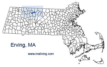
Erving, Massachusetts is a residential community located off Route 2, a busy Mass state highway. The town itself is small, with limited shopping but several popular local restaurants.
Erving offers access to Miller River for whitewater kayaking and fishing, and Northfield Mountain, for cross country skiing, hiking, and rock climbing. Erving is home to Erving Paper Mill, the world’s largest producer of paper napkins. Erving also lays claim to Laurel Lake and Erving State Forest.
Share any Erving, Mass. information or feature your business, contact us.
Settled: 1730
Incorporated: 1775
County: Franklin
Erving, MA Population:
2008: 1,552
2000: 1,467
1990: 1,372
inns | hotels | resorts | rentals | attractions | dining | real estate
SUGGESTED MA BERKSHIRES LODGING Visit Western MA Vacation Specials. Browse current Amherst MA area vacation rentals, inns, resorts, and pet-friendly lodging availabilities below.ERVING MA GIFTS
- *STABLE FOR LONG TIME USE: the floral tote bag is made of canvas, sturdy and reliable, not easy to break, fade or deform, washable and can be applied for many times, supporting you for long service.
- *PRODUCT SIZE:tote measures 15.35 inches (39cm) tall and 13.38 inches (34cm) wide ,handle length:11.02 inches (28cm) .
- *MULTI-PURPOSE GIFT BAGS:The one-shoulder canvas bag is suitable for office, business / quick shopping , appointments, weekends, gifts, birthdays, anniversaries, beaches, diaper bags, travel bags, etc.
- *Perfect Gift:the large tote bags for women can be applied as gifts to send to your friends, neighbors, relatives or colleagues, people will feel happy after receiving these gifts, and they can create a stylish lifestyle.
- *WASH CARE:these travel totes for women carry on are machine washable, light weight, foldable & packable.
- Beautiful bays Massachusetts
- 16-18 inch chain
- 14K gold plated zinc, Nickel free
- Trendy outlined necklaces to wear your pride!
- Charm is about .5"
- 【Multi-function bag】:This cosmetic bag can store not only lipstick, foundation, eye shadow and other cosmetics, but also daily necessities and valuables, such as headphones, keys, camera, shaving kit, etc. It can also contain some daily necessities, such as glasses,Contact eye box, keys, headphones, mobile phone tissue medicine and so on.
- 【Travel Bag】Ideal for travel,vacation,business trip,gym,camping,bathroom organization and outdoor activity, not only it is a simple zipper bag, also it is a functional makeup bag, cosmetic bag, travel organizer bag.Perfect for giving as a gift, or for your own use.
- 【SIZE】23.5 cm ( 9.25 inch ) * 17 cm ( 6.69 inch).TIPS:There are errors in manual measurement.The spacious makeup organizer bag can hold your cosmetics, make up tools, toiletries, or travel essentials.
- 【Materials】:It is made of high quality canvas material. The bag has printed pattern. It is scratch-resistant, durable, waterproof .Convenient travel to carry and store cosmetics
- 【PERFECT GIFT】 This makeup bag is not only suitable for your own use,and this makeup bag would also make a good choice to use as a gift for women, BFF, friends, family for various occasions like birthday, Christmas Day, Mother's Day, Halloween Day,Valentine's Day.
- Vintage Massachusetts MA T-Shirt - Available in Mens, Womens, Kids Tees.
- Massachusetts T-Shirt with state of Massachusetts, year established and state motto The Bay State
- Lightweight, Classic fit, Double-needle sleeve and bottom hem
- Looking for a vintage Massachusetts T-Shirt with a classic old school worn & distressed looking design? This tshirt makes perfect gift or gifts for those who love Massachusetts & for those who call the the Bay State home.
- Massachusetts T Shirt for men, women, kids tees & those from Boston Worcester Springfield Lowell Cambridge Brockton New Bedford Quincy Lynn Newton & all great MA towns.
- Lightweight, Classic fit, Double-needle sleeve and bottom hem
- 【SUITABLE SIZE】Reusable canvas tote Bags, 14.56 inches (37cm) tall and 12.59 inches (32 cm) wide, double Stitched with Two Sturdy Shoulder Straps, soft and durable, and waterproof to a certain degree, so you can use for a long time.
- 【PREMIUM MATERIAL】: Made of high-quality canvas material with marble print, these makeup bags is scratch-resistant, durable and water-resistant, the sturdy gold zipper can keep your beauty products in place.
- 【PERFECT GIFT IDEA】This makeup bag is not only suitable for your own use, but also for gifts. Suitable for different scenes or festivals, to your family, friends, colleagues, etc. Our cosmetic bag is a great choice for holiday gifts, such as birthday, Thanksgiving, Christmas, New Year, Valentine's Day, etc.
- 【MULTI-FUNCTION BAG】:The tote bag is suitable for office, business / quick shopping / bookstore trips, appointments, weekends, gifts, birthdays, anniversaries, graduations, universities, schools, beaches, diaper bags, travel bags, etc.
- 【STABLE FOR LONG TIME USE】: the floral tote bag is made of canvas, sturdy and reliable, not easy to break, fade or deform, washable and can be applied for many times, supporting you for long service.
- ❤Versatile Design for Every Occasion:Whether it's for shopping, travel or daily use, our tote bag complements your style, ensuring you're always prepared.
- ❤Material:Made of Soft polyester material, Exquisite Workmanship,Sturdy Shoulder Straps,Vivid printed and Awesome Quotes,water-resistant and durable fabric protect the things inside your shopping bag,
- ❤Size: 32(12.59inch)*36 cm(14inch), please allow a measurement deviation of 1-2 cm due to manual measurement. Perfect size for enough to hold all your necessities
- ❤Multi-Purpose:Suitable to store your day-to-day makeup,and the big enough to hold your daily items like keys, phones, pen, Sunglasses, notebook while Trips, Vacation, Travel, Office,Running, Shopping, Library,Go To Work,etc.
- ❤Premium Quality:The shopping bag with clear and bright printing, not easy to fade or deform, washable and durable, can be applied for many times.You can use it at wedding, bachelorette party, bridal shower, birthday,etc.
- Vintage style State of Massachusetts souvenir for Massachusetts vacation or Massachusetts travel
- Lightweight, Classic fit, Double-needle sleeve and bottom hem
- this cool boston design with the city map is the perfect gift idea or souvenir for everyone who loves massachusetts.
- Lightweight, Classic fit, Double-needle sleeve and bottom hem
- 【Perfect Gifts】It can be given to friend, family, or gift for yourself, perfect gifts for festivals, such birthday, Christmas, holidays, and more! This is a good choice as a gift for someone special!
- 【Sturdy Zipper & Material】Waterproof zipper cosmetic bag is made of polyester high quality material, which can protect cosmetics, jewelry, and toiletries from water and dust.
- 【Portable & Travel Essentials】Portable Cosmetic Bag size is length 9"x width 6.6"(23*17cm). This makeup supplies organizers bag have enough space to store your toiletries when you travel and cosmetics. It's fashion and versatile. You can also use it to carry glasses, keys, jewelry, and more!
- 【Easy Storage】This cosmetic bag is sewn carefully and evenly, making the bag strong and durable and its sturdy zipper and large interior space, this beauty supplies storage bag can store cosmetics and other items easily.
- 【Multi-purpose】This bag can not only be a cosmetic bag, but also can be used as a clutch, purse, pouch or a bag for party favors. Because of its versatility, you can carry this small but wonderful bag in any occasion!
MASSACHUSETTS TOWN GUIDES
Inns | Hotels | Resorts | Vacation Rentals
Real Estate | Products
Dining | Attractions | Business
History | Weather | Beaches
Fishing | Golfing | Towns
Art Galleries | Massachusetts Shopping
Free World Mall
Country Weddings | New England Recipes
Red Sox Gifts | Paradise Coast Living | New England Living


