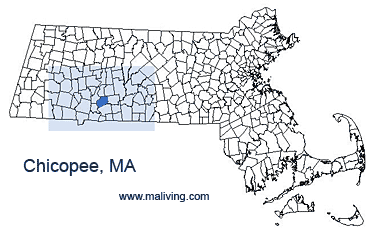
Chicopee, Massachusetts 01013,
Chicopee, Mass. Town Travel Business Information
Chicopee, Massachusetts is nicknamed “Crossroads of New England” because of the four highways that run through the city; Interstates I-90, I-91, I-291, and I-391. These roads provide access to major cities in the surrounding states.
Chicopee is home to Elms College, a four-year, Catholic liberal arts college. The city of Chicopee, Mass rests on the banks of the Connecticut River and is part of the greater Springfield metropolitan area.
Chicopee is separated into five different villages or neighborhoods; Aldenville, Willimansett, Chicopee Center, Chicopee Falls, and Fairview. These neighborhoods were once very distinctively separated by culture, but today they are all compiled of many different types of cultural diversity. The most popular recreational area in the city is Chicopee Memorial State Park. The entire park encompasses 575 acres and includes two swimming and fishing ponds. Jogging and biking, as well as picnicking, are very common activities at the park.
Share Chicopee, Mass. information or feature your business, contact us.
Settled: 1640
Incorporated: 1848
County: Hampden
Chicopee, MA Population:
2008: 54,941
2000: 54,653
1990: 56,632
Chicopee, MA Chamber of Commerce
264 Exchange Street
Chicopee, MA 01013
Ph: 413-594-2101
Fax: 413-594-2103
Additional Town Postal Zip Codes: 01020, 01021
inns | hotels | resorts | rentals | attractions | dining | real estate
SUGGESTED MA BERKSHIRES LODGING Visit Western MA Vacation Specials. Browse current Amherst MA area vacation rentals, inns, resorts, and pet-friendly lodging availabilities below.CHICOPEE MA GIFTS
- 【SUITABLE SIZE】Reusable canvas tote Bags, 14.56 inches (37cm) tall and 12.59 inches (32 cm) wide, double Stitched with Two Sturdy Shoulder Straps, soft and durable, and waterproof to a certain degree, so you can use for a long time.
- 【PREMIUM MATERIAL】: Made of high-quality canvas material with marble print, these makeup bags is scratch-resistant, durable and water-resistant, the sturdy gold zipper can keep your beauty products in place.
- 【PERFECT GIFT IDEA】This makeup bag is not only suitable for your own use, but also for gifts. Suitable for different scenes or festivals, to your family, friends, colleagues, etc. Our cosmetic bag is a great choice for holiday gifts, such as birthday, Thanksgiving, Christmas, New Year, Valentine's Day, etc.
- 【MULTI-FUNCTION BAG】:The tote bag is suitable for office, business / quick shopping / bookstore trips, appointments, weekends, gifts, birthdays, anniversaries, graduations, universities, schools, beaches, diaper bags, travel bags, etc.
- 【STABLE FOR LONG TIME USE】: the floral tote bag is made of canvas, sturdy and reliable, not easy to break, fade or deform, washable and can be applied for many times, supporting you for long service.
- ❤Versatile Design for Every Occasion:Whether it's for shopping, travel or daily use, our tote bag complements your style, ensuring you're always prepared.
- ❤Material:Made of Soft polyester material, Exquisite Workmanship,Sturdy Shoulder Straps,Vivid printed and Awesome Quotes,water-resistant and durable fabric protect the things inside your shopping bag,
- ❤Size: 32(12.59inch)*36 cm(14inch), please allow a measurement deviation of 1-2 cm due to manual measurement. Perfect size for enough to hold all your necessities
- ❤Multi-Purpose:Suitable to store your day-to-day makeup,and the big enough to hold your daily items like keys, phones, pen, Sunglasses, notebook while Trips, Vacation, Travel, Office,Running, Shopping, Library,Go To Work,etc.
- ❤Premium Quality:The shopping bag with clear and bright printing, not easy to fade or deform, washable and durable, can be applied for many times.You can use it at wedding, bachelorette party, bridal shower, birthday,etc.
- UNIQUE: The perfect gift for a fans of Chicopee. Be a real head turner with this original design and a Great conversation starter. Turn heads with this awesome MA design.
- GIFT: Perfect Gift for People who love Chicopee , MA. Great Gift for visiting Massachusetts , awesome gift for kids, youth, daughter, son, mom & dad, papa, father, husband, boyfriend, or friends.
- Lightweight, Classic fit, Double-needle sleeve and bottom hem
- Looking for a vintage Massachusetts T-Shirt with a classic old school worn & distressed looking design? This tshirt makes perfect gift or gifts for those who love Massachusetts & for those who call the the Bay State home.
- Massachusetts T Shirt for men, women, kids tees & those from Boston Worcester Springfield Lowell Cambridge Brockton New Bedford Quincy Lynn Newton & all great MA towns.
- Lightweight, Classic fit, Double-needle sleeve and bottom hem
- Massachusetts Girl Identity design. Sister,Lovely Gift For Daughter And Grand Daughter,Cool Gift For Son And Grandson,Cute Gift For Mom And Great Gift For Girlfriend And Boyfriend,Awesome Gift For Wife And Husband,Perfect Gift For Aunt And Grandma,Cute Gift For Sister And Brother
- This graphic tee is also great for Halloween gifts, birthday gifts, anniversary gift, Mother's Day, New Year gift, Christmas gifts, Thanksgiving gifts, Father's Day, gift for mom, daughter, sister, aunt, nana, grandma, girl, wife, girlfriend
- Lightweight, Classic fit, Double-needle sleeve and bottom hem
- Wear this Chicopee Massachusetts MA tee to show how proud you are of where you come from. Birthday gifts idea for Men Women & Kids.
- Great way to show your hometown pride. Souvenir for your mom dad grandma grandpa boyfriend girlfriend those who love & proud to be from Chicopee Massachusetts MA.
- Lightweight, Classic fit, Double-needle sleeve and bottom hem
- This design is a great gift for men or women because it represents Springfield, Chicopee, Pittsfield, Westfield, Holyoke, Northampton, Agawam Town, West Springfield Town, Amherst Center, Greenfield Town and lots of small towns in western Massachusetts.
- Show your pride if you're from Ware, Adams, South Amherst, Turners Falls, Williamstown, Wilbraham, Belchertown, Great Barrington, Monson Center, Lee, South Deerfield, Shelburne Falls, Holland, Granby, Hatfield, Millers Falls, Housatonic or Deerfield.
- Lightweight, Classic fit, Double-needle sleeve and bottom hem
- Show Off your Love for Chicopee Falls Massachusetts MA while looking Cool and Stylish with this Adored Hometown Souvenir
- Timeless Classic and Versatile Style: Your Chicopee Falls Massachusetts MA Attire is your Go-To Outfit for Every Occasion
- Lightweight, Classic fit, Double-needle sleeve and bottom hem
- Chicopee Massachusetts. Classic Chicopee MA design. Standard Chicopee logo. Chicopee Massachusetts apparel design. Simple Chicopee MA text image. Chicopee Massachusetts map. Chicopee Massachusetts flag.
- Chicopee Massachusetts. Chicopee gear. Chicopee souvenir. Chicopee MA logo. Southern Minimalist style. Chicopee Massachusetts vacation.
- 16” x 16” bag with two 14” long and 1” wide black cotton webbing strap handles.
- Made of a lightweight, spun polyester canvas-like fabric.
- All seams and stress points are double-stitched for durability, and the reinforced bottom flattens to fit more items and hold larger objects.
- Spot clean/dry clean only.
- Throwback Chicopee Massachusetts t-shirt that makes the perfect souvenir gift for family and friends! Show your Chicopee pride by wearing this Retro distressed Chicopee tee.
- Our t-shirt graphics are distressed to give a vintage classic look.
- Lightweight, Classic fit, Double-needle sleeve and bottom hem
MASSACHUSETTS TOWN GUIDES
Inns | Hotels | Resorts | MA Vacation Rentals
Real Estate | Products
Dining | Attractions | Business
History | Weather | Beaches
Fishing | Golfing | Towns
Art Galleries | Massachusetts Shopping
Free World Mall
Country Weddings | New England Recipes
Red Sox Gifts | Paradise Coast Living | New England Living


